OUT AND ABOUT: A poignant memorial to a firefighting tragedy near Baker City
Published 6:00 am Friday, August 1, 2025


The great plane, built to spill fire and death from its belly, was reborn for the opposite purpose.
Its cargo doused flames instead of spawning them.
Until it went down, slamming into the very forest it was summoned to spare.
Trending
The Anthony Fire is not so well-known as it once was.
Several fires in Northeastern Oregon have surpassed its toll of 20,000 acres scorched in July 1960, some many times over.
But none was as deadly.
The dry lightning storm that ravaged the region on July 19, 1960, its bolts igniting at least 80 fires, ultimately killed three people.
None was overrun by flames or suffocated by smoke.
The three deaths resulted from a pair of aircraft crashes, both in southern Union County.
Trending
On Aug. 2, 1960, a two-seat helicopter surveying the fire, which was by then controlled, crashed near High Mountain, a series of modest summits several miles northeast of Anthony Lakes. The passenger was Wilson C. Holroyd, the 31-year-old ranger for the Forest Service’s Baker Ranger District, where two lightning fires had merged to form the Anthony Fire, which burned in both Baker and Union counties.
Although Holroyd survived the crash, he died six days later, on Aug. 8, 1960, from severe head wounds. The pilot survived.
The first aerial tragedy happened on July 22, 1960, a mile or so from the helicopter crash.
A B-25 plane, a twin-engine bomber built by North American Aviation and converted to drop fire retardant, crashed while fighting the Anthony Fire.
The two crew members, pilot Larry Englert, 38, and Elliott Corbett, 33, both of Portland, died.
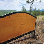
Several years ago I came across, by happenstance, an unconventional but poignant monument that honors the two fliers at the crash site.
It’s not a statue or a plinth or any of the other sorts of structures typically used to memorialize such incidents.
It’s a bench.
A simple construction of wood and steel, sitting at the base of a ponderosa pine.
That tree, like the bench, is something of an anomaly.
The site, a promontory called Rocky Point, is 6,477 feet above sea level (or 6,459 feet — the two maps I consulted disagree on the precise figure).
Notwithstanding the 18-foot discrepancy, the elevation is near the top of the typical range for ponderosas, which most often grow between around 3,500 feet and 6,000 feet in the Blues, depending on location. The species prefers drier sites than most conifers, including lodgepole pines and tamaracks, so ponderosas at higher elevations tend to grow on south-facing slopes, which are warmer and drier due to their greater exposure to sunlight.
Rocky Point is pretty flat. But the trees are scattered so there’s ample sunshine, which I suspect largely explains the presence here of ponderosas.
(By contrast, the steep north-facing slope that plunges off Rocky Point harbors a typical Blue Mountains mixed-conifer forest, with tamarack, lodgepole, subalpine fir and Douglas-fir.)
The bench faces east, and the view from its seat takes in a goodly part of the Anthony Fire. Six and a half decades later, the lodgepoles — that fire-loving pine, with cones that in many cases require extreme heat to release their seeds to germinate — have recolonized most of the land, forming dense stands known by the piquant colloquialism as dog-hair thickets.
My wife, Lisa, and I returned to the site, for the second time, on July 20. It was a fine day for a hike. The temperature was in the low 60s and the north breeze felt more like autumn than mid-summer. Clouds, the vanguards of the storm that doused the Blues the next day, filtered the sunshine.
The memorial to Englert and Corbett is inscribed on the back of the bench.
The front is a tribute, too. “In Memory Of” is etched into the wood. A few names are inscribed.
Bobby Crader, who grew up in La Grande and now lives in Irrigon, said his uncle, Van Dockweiler, placed the bench around 2020, in honor of the B-25 crew and of family and friends for whom this was a favorite hunting spot.
Crader is part of that decades-long tradition.
“We grew up hunting there, all of us,” Crader told me in a phone interview on July 22. “It’s such a beautiful spot up there.”
Crader said his grandfather, Johnnie Dockweiler, worked in the La Grande Watershed during the fire, and that the B-25 tanker was trying to keep flames from spreading into the area.
(La Grande no longer uses the watershed for its drinking water, relying instead on wells, but the land, managed by the U.S. Forest Service, remains a municipal watershed.)
Crader said one of the people whose name is etched on the front of the bench, Gordon Gorham, was Van Dockweiler’s close friend who died in 2015. Another engraved name is that of Alvin Dockweiler Sr., Van’s brother, who died in 2019.
Alvin’s son, Alvin Dockweiler II, said he has spent many hours sitting on the bench during hunting trips.
As Lisa and I walked around the point, looking down at the rockslide on its north side, I thought about this bench, this monument.
I imagined how the snow, come fall, will climb up the metal legs and eventually, inexorably, cover the seat. This is a land of considerable snow, and I suspect that each winter the bench disappears altogether.
It pleases me to know it’s there.
To know that two men who died young are not forgotten, that their heroism lives anew whenever someone who doesn’t know their story happens to come to this lonely and beautiful place.
If you are among them, please treat the bench with the respect that it, and all those who now or in the future are honored on its surfaces, deserve.
IF YOU GO….
Rocky Point is near the southern end of the La Grande Watershed, on the Wallowa-Whitman National Forest. The memorial bench is about 1.7 miles from a locked gate that blocks motor vehicles from continuing.
To get there, drive Forest Road 43, the Ladd Canyon Road. If you’re coming from Baker City or points south, the easiest route is to start where Road 43 meets the Elkhorn Drive Scenic Byway, the turnoff to Grande Ronde Lake about half a mile west of Anthony Lakes Mountain Resort.
Follow Road 43 about 8 miles north to the junction with Forest Road 5125.
If you’re coming from La Grande or points north, drive Interstate 84 to the Ladd Creek exit, a mile or so south of the Charles Reynolds Rest Area. Follow Road 43 about 23 miles to the Road 5125 junction.
Road 43 is well-graded gravel from the freeway to the junction.
The 8 miles from Elkhorn Drive, by contrast, are rough and dusty.
Whichever way you come from, head west on Road 5125 for a few hundred yards to Road 900, which takes off to the north (right). Road 900 is blocked by the gate, but nonmotorized travel is allowed.
Rocky Point is about 1.7 miles to the north, by way of Roads 900 and 910. The latter all but disappears in places, indistinct as it crosses fields of basalt, and the last tenth of a mile or so isn’t on a road at all. But if you stay on the highest ground, until it drops away, you should get there.
Jayson Jacoby is the editor of the Baker City Herald. Contact him at 541-518-2088 or jayson.jacoby @bakercityherald.com.
Marketplace


-
eEdition

-

-
